
Heritage Rating:  for more information on ratings press here
To listen to:
Liszt’s Concerto for piano and orchestra click the arrow below
Oton’s Old Church & Lady CayCay, January 1948
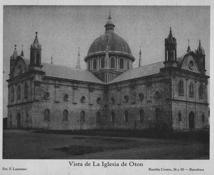
Church of the Immaculate Conception, Oton
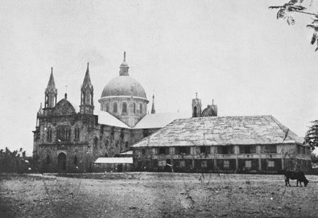
Immaculate Conception Church, Oton, Iloilo (pre-1948)
In researching another project we accidentally came upon some news reports and photos on the Lady CayCay Earthquake of January 25th, 1948 and its effects in the Oton and Iloilo areas. We were amazed by some of these historically significant photos.
[It should be noted, that we have not been able to determine the copyright owner of any of these photos or in indeed they might be in "the public domain" by now. We do not wish to infringe on anyone's rights under current copyright laws and if the owner/owners of any of these photos identify themselves and allow us to continue to display the photos, we will happy add the necessary and appropriate credits to each of those photos.]
This report is based reports from the Manila Times on January 26th and 27th, 1948 following the Lady CayCay Earthquake which occurred at about 1:30AM on January 25th, 1948
The Earthquake swept away many of Iloilo’s Spanish-Era Churches
Iloilo which had not totally recovered from the World War II economic troubles due to the reconstruction.
When the earthquake hit on January 25, 1948 at 1:46 AM. It was reported that the shaking lasted an estimated one to three minutes and this was followed by a series of aftershocks which were felt until 5:52 AM.
The Earthquake’s Epicentre was determined to be at 10.5˚ North Latitude; 122.0˚ East Longitude and its magnitude was fixed at an intensity 8.2 on the Richter Scale. This epicentre was plotted to be in the are of the boundary between the towns of Anini-y and Dao in Antique (now called Tobias Fornier).
Severely Damaged Churches
From the information gathered, several of the churches which collapsed or were so severely damaged that they were eventually had to be completely demolished. Some of them were located in Igbaras, San Miguel and Maasin. According to newspaper accounts:
- the church and convent of the town of Igbaras collapsed. The Jaro archives described the damage as a “total collapse”.
- The church of Maasin was demolished. A new church structure was built beside the former location.
- Falling debris from the collapsing church in San Miguel fell and killed a policeman doing his rounds when the earthquake struck.
More Destruction of Churches
The walls and altar, roof and belfy of the Molo Church were shattered to pieces.
Damage costs in Guimbal were estimated to be P 35,000 as reported by The Manila Times, on January 27th, 1948.
The churches of Pavia and Tubungan were also badly damaged.
The UNESCO-heritage church of Miagao was severely damaged by the earthquake (Jaro archives, 1948). In addition, the newly-constructed municipal building was reported to be a complete wreck and damage costs were estimated to be P30,000.
The Spanish-era Taytay Boni Bridge in Miagao survived the earthquake.
The earthquake severely damaged the church and convent of the town of Santa Barbara. The temporary belfry, the roof and ceiling along with a portion of the altar and the facade collapsed. The communion rail was seriously damaged. Large cracks were observed throughout the church.
The damage estimate for the Tigbauan Church was P50,000.
A very large portion of the province of Iloilo lies in soft ground and one of the possible reasons why the earthquake was called “caycay” was due to what was referred to as “chicken scratches” on the ground, they apparently caused fissures especially in the low lying parts of the province, Fissures were reported along the roads from the town of Pototan to Dingle and along the Santa Barbara railroad tracks.
Ground disruptions described as “little canyons”, possibly the sand blows, were observed in Pototan, Cabatuan, Dingle, Passi and Calinog.
A small brook appeared after huge cracks appeared at the Tiring Landing field (current site of the new Iloilo Airport in Cabatuan).
At Fort San Pedro in Iloilo City, large fissures measuring 4 m wide and 10 meters long opened and were so extensive that sea water was visible in their bottoms. In the Fort San Pedro area of Iloilo City the damage was estimated at about P 10,000.
At the same time large fissures were also observed in the streets of Oton.
The Oton Church crumbled.
In the town of Oton, the biggest and most beautiful church, in the region, which was not destroyed during the war was so severely damaged that it had to be demolished.
The earthquake also destroyed the tower leaving only two bells and stone stumps (Gallende 1990). A boy was buried in the rubble. The earthquake was measured at an Intensity of 9 in Oton and the surrounding areas. Generally speaking, bridges, communication lines, public and private buildings all sustained heavy damage.
After Lady CayCay.
We have found more photos of the Church of the Immaculate Conception in Oton at and after the time of the Lady CayCay Earthquake.
As mentioned above, we have not been able to clearly establish whether these photos are in fact in the Public Domain or are covered by existing Copyrights – we therefore publish them, without prejudice, for the sole purpose of providing our readers and visitors with additional information on this historical disaster.
We will willingly credit the photos, should the copyright owners come forward and identify themselves.
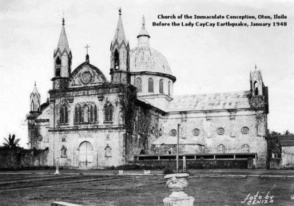
Old Oton Church before 1948 (photo from Mill Hill Missionaries Collection)
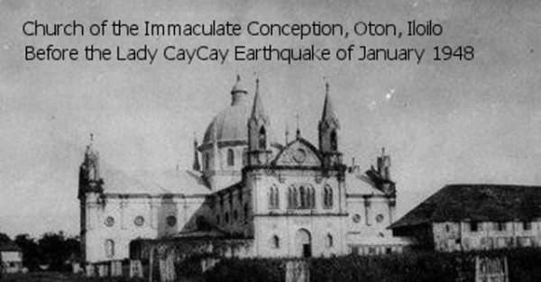
Old Oton Church
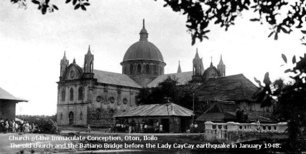
The Old Oton Church & the Spanish era Batiano Bridge
(photo from Mill Hill Missionaries Collection)
(photo from Mill Hill Missionaries Collection)
As we mentioned earlier in this article, the ‘Quake which was measured at 8.2 on the Richter scale hit the area starting at about 1:48 AM on January 25th, 1948 and the shaking, was apparently estimated to have lasted up to 3 minutes followed by a series of aftershocks which were felt until 5:52 AM. (I felt the shaking of the quake that happened in February 2012 which was only a magnitude 4.9 and lasted only about 30 seconds, at most. I was scared witless and the shaking seemed to last forever.) I cannot imagine being caught by Lady CayCay with the shaking being almost twice as violent as the small quake of 2012, but lasting an eternity at about 3 minutes.
Here is what the Oton Church looked like in the aftermath:
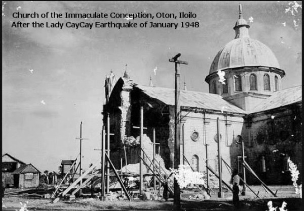
The aftermath of Lady CayCay (photo from Mill Hill Missionaries Collection)
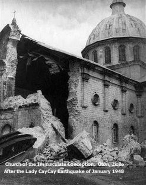
A closer look at the damage (photo from Mill Hill Missionaries Collection)
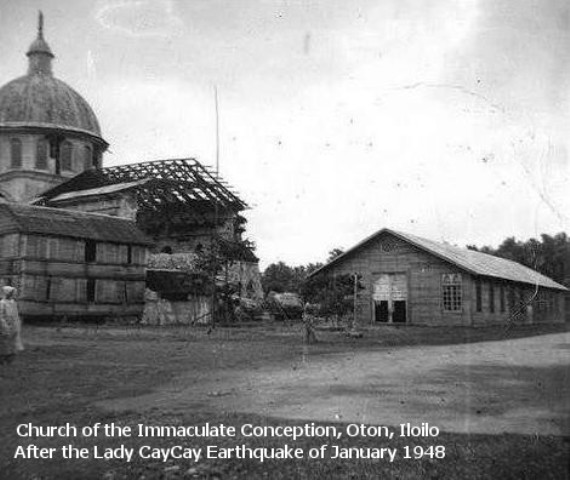
another longer view of the damage (photo from Mill Hill Missionaries Collection)
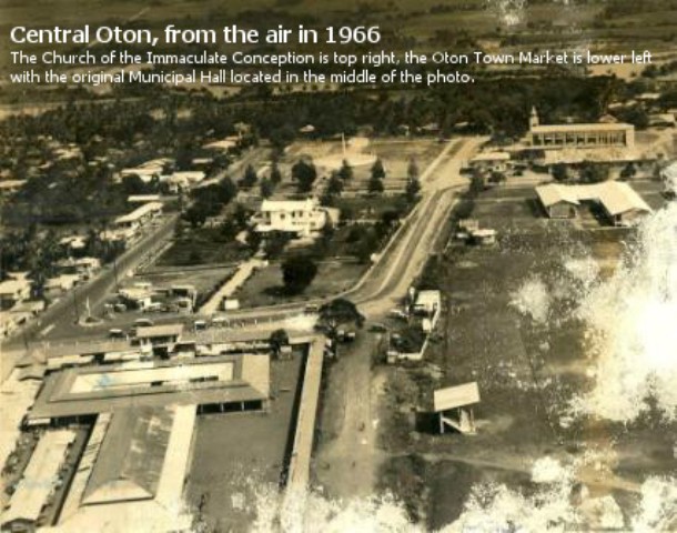
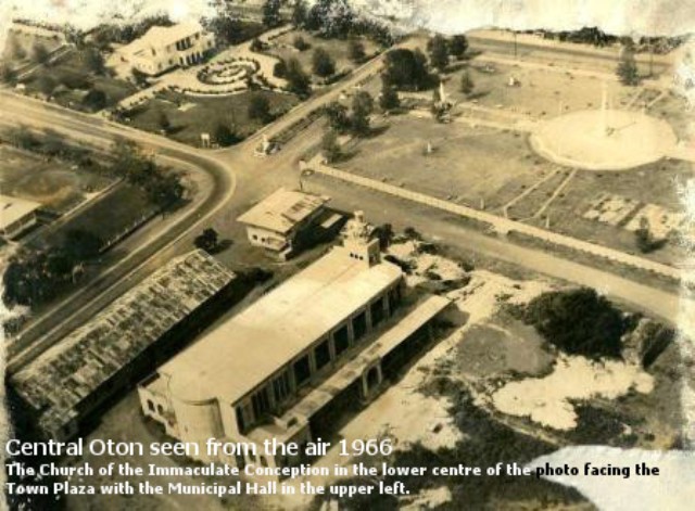
It took the parish until the mid-1960s to reconstruct their church. Here are two arial photos taken of Oton in 1966 while the church was in the final stages of construction. It is interesting to see the area of downtown Oton at the time and witness how it has developed since then.
And, here is how the church looks today!


This work is licensed under a Creative Commons Attribution-ShareAlike 3.0 Unported License.
 (0)Dislikes(0)